Tennessee 2010 Census Report

by Randy Gustafson |print pdf |Flash flip-book «previous | next»

Trousdale County Sequatchie County Moore County Decatur County Loudon County Rhea County Lewis County Chester County Fentress County Houston County Cheatham County Putnam County Union County Bradley County Crockett County Tipton County Wilson County Marshall County Van Buren County Marion County Hardin County Warren County Jackson County Anderson County Hawkins County Fayette County Lake County Benton County Williamson County DeKalb County McMinn County Grainger County Washington County Cocke County Perry County Lauderdale County Meigs County Franklin County Cumberland County Madison County Hickman County Scott County Weakley County Johnson County Clay County Lawrence County Blount County Sumner County Bedford County Roane County Carroll County Coffee County Unicoi County Hamblen County Smith County Giles County Dyer County Claiborne County Hamilton County Stewart County Hardeman County Carter County Bledsoe County Dickson County Morgan County Henderson County McNairy County Sevier County Knox County Rutherford County Overton County Robertson County Henry County Sullivan County Grundy County Jefferson County Maury County Lincoln County Cannon County Humphreys County Greene County Pickett County Haywood County Obion County Montgomery County Wayne County Gibson County Shelby County Macon County White County Campbell County Hancock County Monroe County Polk County Davidson County

[ larger view ]

legend


Population Density Tennessee = 153.9

Population Density, 2010


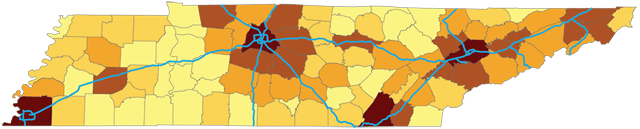
A look at population density in Tennessee in 2010 shows the impact of the interstate highway system on land development. All of the counties with a population density higher than the statewide average of 153.9 persons per square mile are adjacent to one of the state's major highways. In fact the few places that are near an interstate but not highly developed can be explained as direct results of topography. Interstate 40 crosses the Tennessee River in west Tennessee in an area that is characterized as marshy and otherwise inhospitable to settlement. Likewise the low density area northwest of Chattanooga is very steep terrain that is difficult to develop. The map shows population density by county in Tennessee.

All counties with a population density higher than the statewide average of 153.9 persons per square mile are adjacent to one of the state's major highways.
  Randy Gustafson is the director of the Tennessee State Data Center.